 The
Global Positioning System (GPS) is a global navigation satellite system
(GNSS) developed by the United States Department of Defense and managed
by the United States Air Force 50th Space Wing. It is the only fully
functional GNSS in the world, can be used freely by anyone, anywhere,
and is often used by civilians for navigation purposes. It uses a
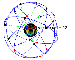
constellation of between 24 and 32 medium Earth orbit satellites that
transmit precise radio wave signals, which allow GPS receivers to
determine their current location, the time, and their velocity. Its
official name is NAVSTAR GPS. Although NAVSTAR is not an acronym, a few
backronyms have been created for it.
The
Global Positioning System (GPS) is a global navigation satellite system
(GNSS) developed by the United States Department of Defense and managed
by the United States Air Force 50th Space Wing. It is the only fully
functional GNSS in the world, can be used freely by anyone, anywhere,
and is often used by civilians for navigation purposes. It uses a
constellation of between 24 and 32 medium Earth orbit satellites that
transmit precise radio wave signals, which allow GPS receivers to
determine their current location, the time, and their velocity. Its
official name is NAVSTAR GPS. Although NAVSTAR is not an acronym, a few
backronyms have been created for it.
A GPS receiver calculates its position by precisely timing the signals
sent by the GPS satellites high above the Earth. Each satellite
continually transmits messages containing the time the message was sent,
precise orbital information (the ephemeris), and the general system
health and rough orbits of all GPS satellites (the almanac). The
receiver measures the transit time of each message and computes the
distance to each satellite. Geometric trilateration is used to combine
these distances with the location of the satellites to determine the
receiver's location. The position is displayed, perhaps with a moving
map display or latitude and longitude; elevation information may be
included. Many GPS units also show derived information such as direction
and speed, calculated from position changes.
It might seem three satellites are enough to solve for position, since
space has three dimensions. However, even a very small clock error
multiplied by the very large speed of light[19]—the speed at which
satellite signals propagate—results in a large positional error.
Therefore receivers use four or more satellites to solve for x, y, z,
and t, which is used to correct the receiver's clock. While most GPS
applications use the computed location only and effectively hide the
very accurately computed time, it is used in a few specialized GPS
applications such as time transfer, traffic signal timing, and
synchronization of cell phone base stations.
Although four satellites are required for normal operation, fewer apply
in special cases. If one variable is already known (for example, a ship
or plane may have known elevation), a receiver can determine its
position using only three satellites. Some GPS receivers may use
additional clues or assumptions (such as reusing the last known
altitude, dead reckoning, inertial navigation, or including information
from the vehicle computer) to give a degraded position when fewer than
four satellites are visible
Hand held GPS
The user's GPS receiver is the user segment (US) of the GPS. In general,
GPS receivers are composed of an antenna, tuned to the frequencies
transmitted by the satellites, receiver-processors, and a highly-stable
clock (often a crystal oscillator). They may also include a display for
providing location and speed information to the user. A receiver is
often described by its number of channels: this signifies how many
satellites it can monitor simultaneously. Originally limited to four or
five, this has progressively increased over the years so that, as of
2007[update], receivers typically have between 12 and 20 channels.[34]
A typical OEM GPS receiver module measuring 15×17 mm.
GPS receivers may include an input for differential corrections, using
the RTCM SC-104 format. This is typically in the form of a RS-232 port
at 4,800 bit/s speed. Data is actually sent at a much lower rate, which
limits the accuracy of the signal sent using RTCM. Receivers with
internal DGPS receivers can outperform those using external RTCM data.
As of 2006, even low-cost units commonly include Wide Area Augmentation
System (WAAS) receivers.
A typical GPS receiver with integrated antenna.
Many GPS receivers can relay position data to a PC or other device using
the NMEA 0183 protocol, or the newer and less widely used NMEA 2000.[35]
Although these protocols are officially defined by the NMEA,[36]
references to these protocols have been compiled from public records,
allowing open source tools like gpsd to read the protocol without
violating intellectual property laws. Other proprietary protocols exist
as well, such as the SiRF and MTK protocols. Receivers can interface
with other devices using methods including a serial connection, USB or
Bluetooth.
Navigation signals
GPS broadcast signal
Each GPS satellite continuously broadcasts a Navigation Message at 50
bit/s giving the time-of-week, GPS week number and satellite health
information (all transmitted in the first part of the message), an
ephemeris (transmitted in the second part of the message) and an almanac
(later part of the message). The messages are sent in frames, each
taking 30 seconds to transmit 1500 bits.
Transmission of each 30 second frame begins precisely on the minute and
half minute as indicated by the satellite's atomic clock according to
Satellite message format. Each frame contains 5 subframes of length 6
seconds and with 300 bits. Each subframe contains 10 words of 30 bits
with length 0.6 seconds each.
Words 1 and 2 of every subframe have the same type of data. The first
word is the telemetry word which indicates the beginning of a subframe
and is used by the receiver to synch with the navigation message. The
second word is the HOW or handover word and it contains timing
information which enables the receiver to identify the subframe and
provides the time the next subframe was sent.
Words 3 through 10 of subframe 1 contain data describing the satellite
clock and its relationship to GPS time. Words 3 through 10 of subframes
2 and 3, contain the ephemeris data, giving the satellite's own precise
orbit. The ephemeris is updated every 2 hours and is generally valid for
4 hours, with provisions for updates every 6 hours or longer in
non-nominal conditions. The time needed to acquire the ephemeris is
becoming a significant element of the delay to first position fix,
because, as the hardware becomes more capable, the time to lock onto the
satellite signals shrinks, but the ephemeris data requires 30 seconds
(worst case) before it is received, due to the low data transmission
rate.
The almanac consists of coarse orbit and status information for each
satellite in the constellation, an ionospheric model, and information to
relate GPS derived time to Coordinated Universal Time (UTC). Words 3
through 10 of subframes 4 and 5 contain a new part of the almanac. Each
frame contains 1/25th of the almanac, so 12.5 minutes are required to
receive the entire almanac from a single satellite.[37] The almanac
serves several purposes. The first is to assist in the acquisition of
satellites at power-up by allowing the receiver to generate a list of
visible satellites based on stored position and time, while an ephemeris
from each satellite is needed to compute position fixes using that
satellite. In older hardware, lack of an almanac in a new receiver would
cause long delays before providing a valid position, because the search
for each satellite was a slow process. Advances in hardware have made
the acquisition process much faster, so not having an almanac is no
longer an issue. The second purpose is for relating time derived from
the GPS (called GPS time) to the international time standard of UTC.
Finally, the almanac allows a single-frequency receiver to correct for
ionospheric error by using a global ionospheric model. The corrections
are not as accurate as augmentation systems like WAAS or dual-frequency
receivers. However, it is often better than no correction, since
ionospheric error is the largest error source for a single-frequency GPS
receiver. An important thing to note about navigation data is that each
satellite transmits not only its own ephemeris, but transmits an almanac
for all satellites.
All satellites broadcast at the same two frequencies, 1.57542 GHz (L1
signal) and 1.2276 GHz (L2 signal). The receiver can distinguish the
signals from different satellites because GPS uses a code division
multiple access (CDMA) spread-spectrum technique where the low-bitrate
message data is encoded with a high-rate pseudo-random (PRN) sequence
that is different for each satellite. The receiver knows the PRN codes
for each satellite and can use this to reconstruct the actual message
data. The message data is transmitted at 50 bits per second. Two
distinct CDMA encodings are used: the coarse/acquisition (C/A) code (a
so-called Gold code) at 1.023 million chips per second, and the precise
(P) code at 10.23 million chips per second. The L1 carrier is modulated
by both the C/A and P codes, while the L2 carrier is only modulated by
the P code.[38] The C/A code is public and used by civilian GPS
receivers, while the P code can be encrypted as a so-called P(Y) code
which is only available to military equipment with a proper decryption
key. Both the C/A and P(Y) codes impart the precise time-of-day to the
user.
Satellite frequencies for GPS
* L1 (1575.42 MHz): Mix of Navigation Message, coarse-acquisition (C/A)
code and encrypted precision P(Y) code, plus the new L1C on future Block
III satellites.
* L2 (1227.60 MHz): P(Y) code, plus the new L2C code on the Block IIR-M
and newer satellites.
* L3 (1381.05 MHz): Used by the Nuclear Detonation (NUDET) Detection
System Payload (NDS) to signal detection of nuclear detonations and
other high-energy infrared events. Used to enforce nuclear test ban
treaties.
* L4 (1379.913 MHz): Being studied for additional ionospheric
correction.
* L5 (1176.45 MHz): Proposed for use as a civilian safety-of-life (SoL)
signal (see GPS modernization). This frequency falls into an
internationally protected range for aeronautical navigation, promising
little or no interference under all circumstances. The first Block IIF
satellite that would provide this signal is set to be launched in
2009.[39]
more info:
http://en.wikipedia.org/wiki/Global_Positioning_System
My Blog:
http://bigworld-smallworld.blogspot.com/2009/06/what-is-gps-marine.html